


Youlgreave to Lathkill Dale Circular Walk
Deserted medieval settlements and limestone crags combine in this easy hike through one of the most atmospheric landscapes in the Peak District.


Humans will make their mark on nature, and nature will always find a way to reclaim. When human influences happened centuries ago, you're left with landscapes where it’s impossible to tell where human hands end and nature begins.
This circular hike through Youlgreave and Lathkill Dale is a living example. It’s a testament to both human industrial ambition and nature’s quiet, relentless power to thrive in any landscape. The pastoral fields around Youlgreave and Conksbury quickly yield to the jagged limestone towers of Lathkill Dale, where ruins and wildflowers intertwine.
⚠️Before you start hiking…
If you’ve ever pored over an OS map, you’ve seen gothic-style font scattered among the contours. For context, the text refers to any site that is non-Roman and carries some historical or archaeological significance.

Visiting them is a gamble. Sometimes, the remains are vivid and dramatic — stone circles, ancient settlements, even rock art. Other times, you're standing in a barren field wondering if you missed something. That’s part of the adventure: learning to read the subtle clues in the landscape.
So, consider this walk a training ground, not just for your legs, but for your eyes. Whether ruins are prominent or faint, every visit builds a better knack for spotting history where it hides in the natural landscape.
Ghost towns in the grass

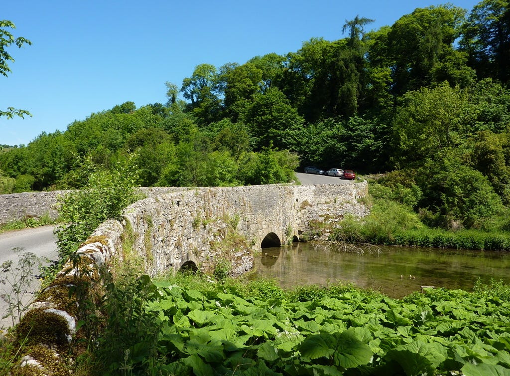
The trail begins in the historic village of Youlgreave (see my Nine Stones Circuit walk for a different perspective), but this route quickly veers into less-trodden terrain. Heading north, you’ll arrive at the deserted medieval settlement of Conksbury.
Today, a few grassy mounds and a faint rectangular platform hint that a village once stood here. In fairness, Conksbury never had a chance to get off the ground.
According to the Domesday Book, roughly 6.8 households existed in Conksbury in the 11th century, putting it in the bottom 40% of settlements in England1.
Over the centuries, Conksbury was passed between knights, abbeys, and priories like a game of real estate pass-the-parcel, until Henry VIII dissolved the monasteries and left places like this to fade into the landscape.
Now it’s a quiet, tufted field. Perhaps that’s how its inhabitants always saw it, too. A small settlement, hemmed in by fields and sky.
Limestone fortresses and mining ingenuities

From Conksbury, the route flows into Lathkill Dale, where limestone cliffs rise like fortresses and nature and industry blend in strange harmony.
Between the 13th and 19th centuries, this dale buzzed with lead mining and milling. Today, remnants of that era still linger. Some signs are subtle, others more striking. You’ll spot shallow mine shafts and test tunnels just metres from the path. Small weirs and ancient ponds, once part of the milling infrastructure, now feed crystal-clear cascades.
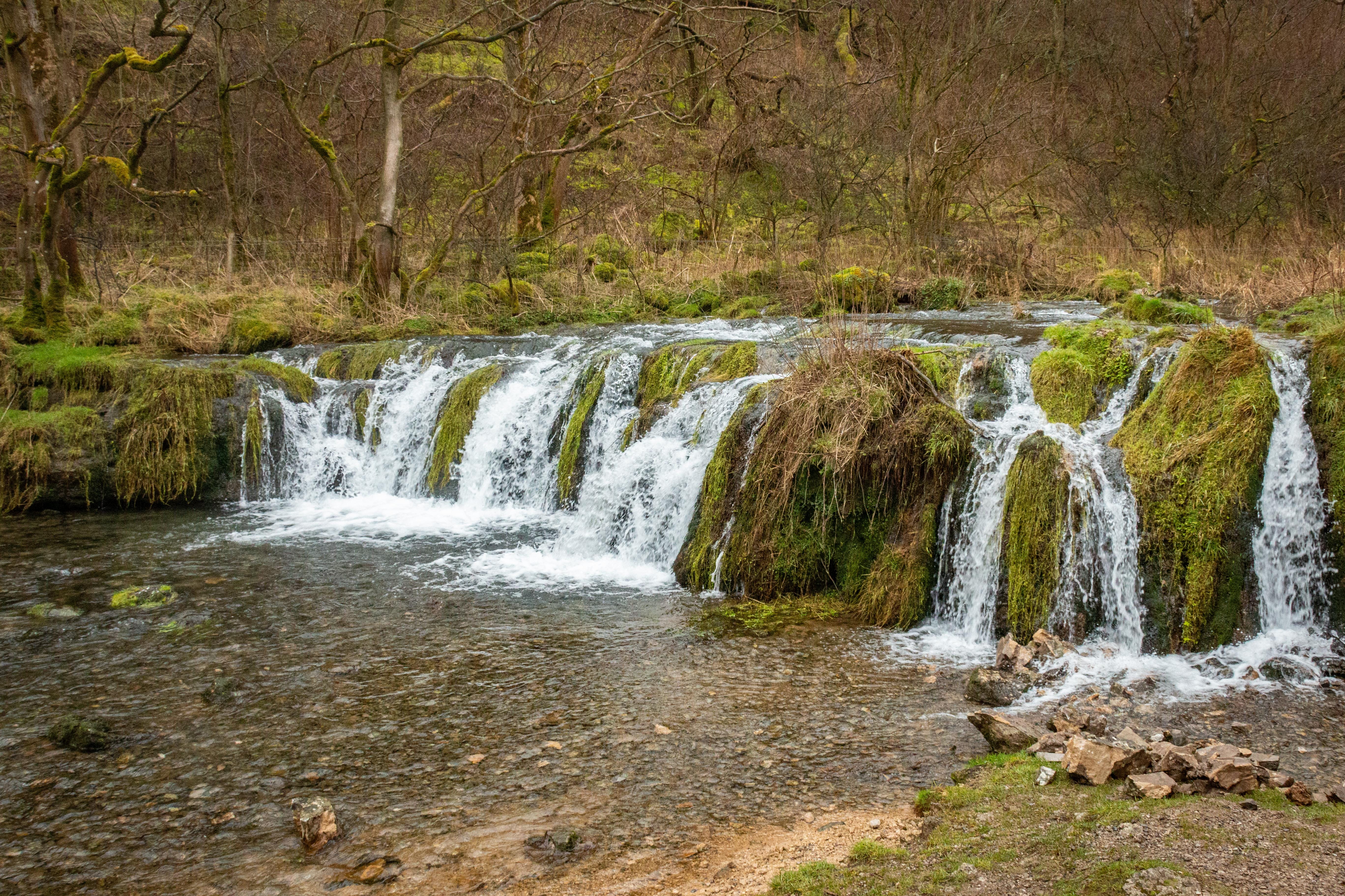
Look closely: the water’s so clear you can trace the midribs of aquatic flora. Engine houses, millstone fragments, and waterwheel structures sit camouflaged in bracken and wildflowers. Birds dart through broken lintels. Trees nestle in collapsed stone.
With the dale’s limestone crags rising all around, it’s not hard to imagine this valley as a setting for ghost stories and folklore.

Enjoy this circular hike between Youlgreave and Lathkill Dale via the GPS file on OS maps. The app will guide you along the route so you have more time to enjoy the history and scenery along the trail.
🥾 Route summary: Youlgreave to Lathkill Dale Circular
Distance: 6.9 miles/11.09 km
Time: approx. 4 hours (depending on pace and stops)
Start/End: Youlgreave village
Terrain: Fields, riverside trails, rocky dale paths, some uneven ground
Difficulty: Moderate (short ascents/descents, muddy sections after rain)
Parking: Coldwell End, Bakewell DE45 1UY. Technically free however I recommend a £3 donation
Highlights:
Deserted medieval village of Conksbury
Lathkill Dale’s dramatic limestone cliffs
Lead mining ruins and waterfalls
Facilities:
Toilets and pubs in Youlgreave
No facilities en route — bring water and snacks
Map: OS Explorer OL24 (White Peak)
Caution: Some paths near mine shafts are narrow; take care near edges
Powell-Smith, Anna. “Conksbury | Domesday Book.” Opendomesday.org, 2025, opendomesday.org/place/SK2165/conksbury/. Accessed 7 Apr. 2025.